

On December 21, Chinese Ministry of Foreign Affairs Spokesperson Mao Ning was asked about a Bloomberg News story reporting that China has been “building up several unoccupied land features in the South China Sea.”
While China has been known to build out islands, reefs and other geographic features in the disputed sea, the report stressed that the alleged Chinese activities would be “the first known instances of a nation doing so on territory it doesn’t already occupy.”
China and the 10-member Association of Southeast Asian Nations (ASEAN) signed in 2002 the non-binding Declaration on the Conduct of Parties in the South China Sea that called on the signing parties to refrain from “inhabiting on the presently uninhabited islands, reefs, shoals, cays and other features” in the South China Sea.
The Philippines Foreign Ministry said that it was “seriously concerned” about the report and “such activities contravene the Declaration of Conduct on the South China Sea's undertaking on self-restraint.”
In response, Mao dismissed the Bloomberg News report as “completely untrue.”
“Refraining from action on the presently uninhabited islands and reefs of the Nansha Islands is a serious common understanding reached by China and ASEAN countries in the Declaration on the Conduct of Parties in the South China Sea (DOC), and China always strictly abides by it.” [Note: The Spratlys Islands are called Nansha Islands by China]
China’s Embassy in Manila called the report “fake news,” according to The Manila Times.
Bloomberg News cited Western officials and presented satellite images that appeared to show the purported Chinese reclamation activities, and the Philippines Foreign Ministry said they have asked relevant agencies to “verify and validate” the report.
Citing Western officials who asked not to be identified to discuss sensitive information, Bloomberg News reported that “fishing fleets that operate as de facto maritime militias under the control of authorities in Beijing have carried out construction activities at four unoccupied features in the Spratly Islands over the past decade,” including Eldad Reef, Lankiam Cay, Whitsun Reef and Sandy Cay.
“Some sand bars and other formations in the area expanded more than 10 times in size in recent years,” the report noted.
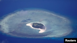
A satellite photo from 2014 shows what the Western officials said was “a Chinese maritime vessel offloading an amphibious hydraulic excavator used in land reclamation projects at Eldad Reef in the northern Spratlys.”
The same satellite photo appeared in a 2014 news report by Philippine Daily Inquirer. It was reported that the Philippines’ military had taken photos “of China’s ongoing reclamation activity on Malvar Reef [note: named Eldad Reef in the Philippines] in February, with the pictures showing a backhoe attached to a Chinese vessel that, scientists said, was presumably used to gather filling materials and harvest giant clams.”
In another satellite photo of Eldad Reef taken on November 4, a small strip of brown-colored land can be seen in the middle of the bluewaters. Bloomberg News, citing the officials, said that new land formations have “appeared above water over the past year” and “images showed a large hole, debris piles and excavator tracks at a site that used to be only partially exposed at high tide.”
The officials told Bloomberg News said that “similar activities have also taken place at Lankiam Cay, known as Panata Island in the Philippines, where a feature had been reinforced with a new perimeter wall over the course of just a couple of months last year.”
Bloomberg News also obtained satellite images that appear to show the physical changes to “a layered land feature at Sandy Cay” between 2009 and 2021.
In a set of four satellite photos, the same land feature went from a small circular land feature on June 19, 2009, to being submerged in the sea on October 1, 2014. In a satellite photo taken on March 22, 2017, it became a slightly larger layered land feature. It expanded even further in a satellite photo taken on February 16, 2021.
Mike Yeo, Asia correspondent for the U.S. national security news website Defense News, used Google Earth to check the locations of interest in the report. He said on Twitter that the search result “does seem to show signs of small-scale reclamation at the locations mentioned by Bloomberg…”
He posted two Google Earth screenshots of Sandy Cay, which he located with decimal degrees 11.074551 and 114.257893, to show “signs of small-scale reclamation between 2018 and 2021.”
Bloomberg News also showed a December 3 satellite photo of Whitsun Reef, where small areas of land features can be seen above water.
“Other images [the officials] presented showed physical changes at both Whitsun Reef and Sandy Cay, where previously submerged features now sit permanently above the high-tide line.”
Yeo also posted four Google Earth screenshots of satellite photos of Whitsun Reef, located with decimal degrees 9.9971507 and 114.6158374, from 2014 to 2019. He said while it was “not wrong that the above-water features change routinely,” the 2019 satellite photo “sure looks like someone’s been pouring layers of sand there.”
Yeo was responding to a statement by the South China Sea Probing Initiative (SCSPI), a Beijing-based think tank affiliated with Peking University’s Institute of Ocean Research.
SCSPI called the Bloomberg News report “100% fake news.” It tweeted shortly after the publication of the report on December 20:
“First, of the four features mentioned, Sandbars and formations of Lankiam Cay, Eldad Reef and Whitsun Reef naturally change every year. Second, Sandy Cay is occupied by Vietnam, where how ridiculous to blame China!”
Responding to SCSPI’s second point, Yeo said the think tank “seem to have mixed up Sand Cay occupied by Vietnam and unoccupied Sandy Cay” and the two are 80 kilometers apart:
“The Bloomberg report is referencing Sandy Cay at 11.074551, 114.257893 which shows signs of small scale reclamation between 2018 and 2021 (pics attached in this tweet).
“The Sand Cay occupied by Vietnam is at 10.374840, 114.48051, or roughly 80km to the SSE.”
Other journalists and Asia experts also commented that Vietnam-occupied Sand Cay is not Sandy Cay.
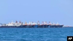
The South China Sea is one of the world’s most heavily trafficked waterways and most disputed territories in the world. Beijing and six other governments, including the Philippines, Vietnam, Indonesia, Malaysia, Taiwan and Brunei claim sovereignty over rocks, reefs and other geographic features of the region.
China has been making the most sweeping claims by asserting “indisputable sovereignty over the islands in the South China Sea and the adjacent waters” based on what have become known as the “nine-dash line.” According to the U.S. Department of State, the nine-dash line would enclose about 62% of the sea.
Even though an UNCLOS arbitral tribunal ruled in 2016 that China’s nine-dash line had “no legal basis,” China declared the ruling “null and void” and kept sending vessels to the disputed land features.
In the South China Sea, China has a track record of ignoring international laws and disrupting other claimants’ attempts to assert their rights by intimidation and bullying.
The region has increasingly become a flashpoint between the neighboring countries with China’s rapid expansion and its increasing number of naval and coast guard ships in the region to enforce is claims. Polygraph.info has extensively reported on China’s disregard of United Nations Convention on the Law of the Sea (UNCLOS) and its repeated distortions of history and facts about the region.
Earlier this month, Manila expressed “great concern” over the reported swarming of Chinese vessels in the vicinity of Iroquois Reef and Sabina Shoal, both located in the Philippines’ Exclusive Economic Zone (EEZ) according to the UNCLOS. However, the two are also claimed by China that called them Houteng Jiao and Xianbin Jiao, respectively.
The Philippines brought a case to the international tribunal in 2013 over China’s actions in the South China Sea. Apart from declaring China’s nine-dash line without legal basis, the tribunal also ruled in 2016 “that none of the land features in the Spratlys is entitled to any more than a 12-nm territorial sea; three of the Spratlys features that China occupies generate no entitlement to maritime zones; and China violated the Philippines’ sovereign rights by interfering with Philippine vessels, damaging the maritime environment, and engaging in reclamation work on a feature in the Philippines’ EEZ,” according to a report by the Congressional Research Service, the non-partisan research agency that works for the U.S. Congress.
In November, a Philippine military commander reported that a Chinese coastguard ship “forcefully retrieved” a piece of a rocket floating in the sea that was being towed by a Philippine vessel, Reuters reported. The commander said that the Chinese coastguard ship did so by cutting a line attaching the object to a Philippine boat.
Beijing denied use of force and said the Philippines “handed over” the floating object “after both sides had a friendly negotiation at the scene.”
U.S. State Department spokesperson Ned Price voiced concern in a December 19 statement over the reported “escalating swarms” of Chinese vessels and “the unsafe encounter” involving the retrieval of the rocket piece.
He said China’s actions in the region “reflect continuing disregard for other South China Sea claimants and states lawfully operating in the region.”
“The United States stands with our ally, the Philippines, in upholding the rules-based international order and freedom of navigation in the South China Sea as guaranteed under international law.”
The Chinese Embassy in Manila responded by accusing the United States of trying to “drive a wedge" between China and the Philippines and “stir up trouble” in the South China Sea by making “unfounded accusations.”
Following the Bloomberg News report, the Philippines Defense Ministry on December 22 ordered its military to boost its presence in the South China Sea after monitoring “Chinese activities” in disputed waters, Reuters reported. The ministry did not specify what those activities were.